Interactive 3D Map of Vancouver neighbourhoods with color comparisons of benchmark prices.
*Data from REBGV | CREA for HPI Benchmark pricing
As Vancouverites, our team found that every neighbourhood in Vancouver is diverse and special - So deciding between them can be difficult. We wanted an easy way to compare and contrast neighbourhood data but we found that we had to develop our own tools to provide visual comparisons. A picture is worth a 1000 words and our goal is to digest hour(s) worth of data into "quick looks". Visual analysis should be part of everyone's toolkit so we decided to make this section available to every Home Buyer and Seller. Our Vancouver neighbourhood profiles have exclusive infographics and 3D interactive visual map analytics, market activity, MLS statistics, school catchment maps, and census data maps for all area neighbourhoods. Enjoy! Prefer a GUIDED TOUR? -- contact one of our neighbourhood experts for a personal tour. For more immediate needs, feel free to call (604) 307-9506, or if you prefer email: [email protected] and we will get back to you as soon as we can.
Vancouver is a world class city and forms the core of Metro Vancouver (a group of 21 municipalities/cities). As first-time visitors quickly discover, Vancouver is known for her culturally diverse neighbourhoods. The city setting is an urban stage surrounded by many natural surroundings. It is Vancouver's urban connection with mother nature that invites residents to feel more connected to their neighbourhood, surroundings, and community. You will experience this when you visit! Guaranteed. It would take weeks, if not months to see every neighbourhood in Vancouver. Don't worry, our Vancouver experts can guide you. For any immediate needs, feel free to call (604) 307-9506, or if you prefer email: [email protected] and we will get back to you as soon as we can. For first time visitors, we invite you to discover with Tourism Vancouver's website to get a sense of each neighbourhood.
Detached Housing in Vancouver is diverse and ranges from detached wood-framed homes on popular standard lot sizes of 33feet by 120feet to luxury homes on much larger lots. Apartments and Condos are very popular in Vancouver and the smallest bachelor suites are now a cozy < 500 s.f. At the other end of the Condominium spectrum, luxury units are becoming popular options for those looking to live in urban populated areas. Vancouver has very diverse and vibrant cultural communities, good education, mixed green space, and an alluring blend of proximity to nature for both young families as well as a more mature population. Public Transportation is well established for commuters to get around Metro Vancouver affordably. The skytrains, buses, aqua buses, ferries, taxis provide many different modes of transportation. Most places within vancouver can be reached within 5 mins to 1 hour travel time in traffic.

Interactive 3D Map of Vancouver neighbourhoods with demographics of singles, married family, high growth, and dense areas.
*Census data from 2016 Statistics Canada census and CensusMapper.ca.
Traditional Census data provides a wealth of information. However, singular points of data are often meaningless without comparisons -- We decided to provide you a unique visual means of comparison. Once you see the visual patterns, this is extremely powerful. And this is not easily achievable with charts and graphs.
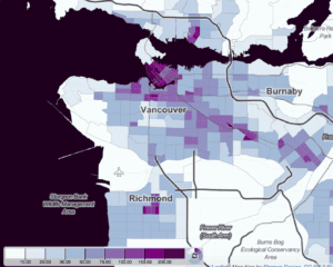
EXAMPLE: Lets take population density of a neighbourhood. As a single data point of density, the information is not very meaningful. However, on a color coded map, the density of Vancouver (dense purple areas) surrounding transportation corridors light up. It is easy to see that Vancity planning has had an effect on dense housing types along skytrain/Kingsway corridor. This useful information is not as easy to convey with just charts and graphs.
Interactive 3D Map of Vancouver neighbourhood school catchments | Elementary, Middle, Secondary
*Notice: Although we try to ensure that the catchment and school information is current, there can be errors or changes. The information in the map above is provided for entertainment purposes only. To check a specific address, please refer to the SD43 school district's school locator tool
Interactive 3D Map of Vancouver neighbourhood MLS listings for Houses, Condos, Townhouse, Duplex
*MLS listings information provided by REBGV and CREA
MLS listings provided to public realtor.ca on MLS are provided directly via MLS. However, as with all MLS listings, there may be pending listings or exclusive listings will not appear on MLS.
Please contact Meryl at 604-307-9506 if you would like to be notified of listings that are pending or exclusive.